
New York City is sinking gradually, and some areas appear to be dropping faster than others, research shows.
A study published in the journal Science last month demonstrated how land across the city is sinking, or subsiding, at varying rates due to human and natural factors, while some locations are even rising, or uplifting.
The study authors from NASA's Jet Propulsion Laboratory (JPL) in Pasadena, California, and Rutgers University, New Jersey, found that that New York City is broadly sinking at an average rate of about 1.6 millimeters (0.06 inches) per year, although there are significant differences across the metropolitan area.
While the rate of elevation change is only a fraction of an inch per year, such processes can enhance or diminish the risk of flooding in any given area as sea levels rise around the world.

"From prior work of our own and others, we know that many coastal areas are sinking, which can make flooding from sea level rise and storms worse," JPL researcher and study author Brett Buzanga told Newsweek.
"We have a powerful satellite technique that can measure this sinking and has shown there can be differences in the speed of land motion from one neighborhood to the next. This information is important when considering how to build resilience at the coast to sea level rise as many locations around the world are doing."
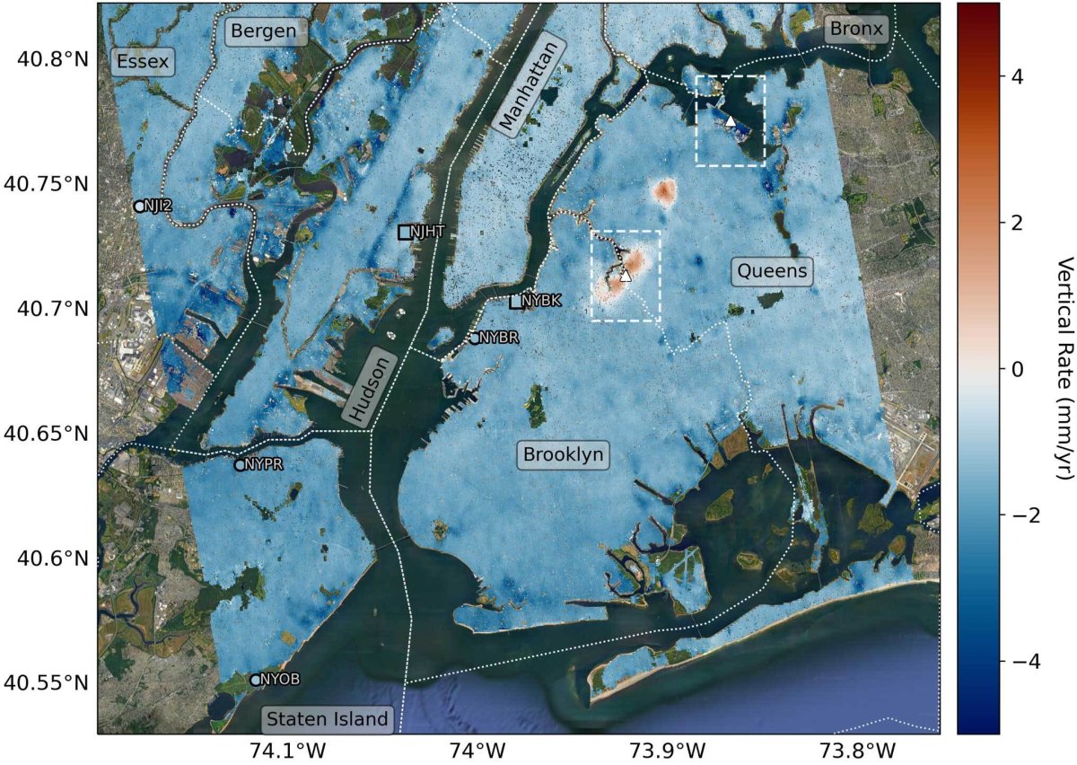
In their study, researchers investigated land motion trends across New York City from 2016 to 2023 using radar data collected by the European Space Agency's Sentinel-1 satellites. They then produced a detailed map of the "vertical land motion" with the data revealing hotspots of subsidence and uplift.
Some of the locations that are experiencing faster rates of sinking include LaGuardia Airport, Arthur Ashe Stadium, parts of Interstate 78, Governor's Island and Rikers Island, among others.
Arthur Ashe Stadium, for example, is sinking at a rate of around 4.6 millimeters (0.18 inches) per year, while one runway at LaGuardia is subsiding at a rate of around 3.7 millimeters (0.15 inches) per year.
While the researchers could not provide a definitive cause for the sinking, they found that most of the subsidence is occurring in areas where prior modification to the ground—such as the reclamation of land and the construction of landfills—has previously taken place.
"We note that places that are sinking the fastest are collocated with landfills and reclaimed [filled in] land which tend to consist of material that is more compressible than something like bedrock, and so sinks faster when loaded with weight," Buzanga said.
Some of the vertical motion may have also been influenced by the retreat of a vast ice sheet that covered most of New England thousands of years ago during the last ice age. After the ice sheet disappeared, Earth's surface in the region has gradually readjusted.
"The most recent large ice age in North America persisted until about 20,000 years ago. The weight of the ice pressed down on the mid-continent, and caused a bulge along the Eastern Seaboard," U.S Geological Survey researcher, Tom Parsons, who was not involved in the Science study, told Newsweek.
"After the ice melted away, the crust is returning to equilibrium, meaning that New York and other parts of the East Coast are subsiding," he said.
Parsons and colleagues previously conducted a separate study on land subsidence in New York, finding that the city was sinking on average around 2 millimeters (0.07 inches) per year—similar to the figure proposed in the Science study. They also identified that some areas were sinking faster than others.
'We made a rough calculation of the downward pressure from all the buildings and their contents on the ground beneath and found a highly variable effect depending on foundation types and local soil conditions," Parsons said.
"In addition, sea level is rising about 2 millimeters per year, meaning that the average relative subsidence is doubled to 4 millimeters per year."
In the Science study, the authors also observed that some isolated areas of New York were uplifting, including Newton Creek in Brooklyn and Woodside in Queens—although the latter stabilized after rising between 2016 and 2019.
While the researchers could not provide a definitive cause for uplift, they noted that groundwater pumping and injection wells used to treat polluted water may have played a role.
Overall though, the city is subsiding, and as sea levels rise, the risk of flooding could worsen, according to the researchers.
"The primary implications of this research are for resilience to ongoing sea level rise and its potential for increased flooding," Buzanga said. "Over the following century and perhaps longer, sea level will continue to rise. The sinking we find here is an important part of the sea level rise that NYC is experiencing.
"Our findings—especially the variations in rate of sinking from neighborhood to neighborhood—can help communities decide how best to respond to current and prepare for future sea level rise."
About the writer
Aristos is a Newsweek science reporter with the London, U.K., bureau. He reports on science and health topics, including; animal, ... Read more
To read how Newsweek uses AI as a newsroom tool, Click here.

